Accessing Accountability Avenues for Ukraine
Assessment of Agricultural Land Loss in Ukraine Due to Russia's Occupation and Evaluation of Production on Occupied Territories
Introduction
Reports of the occupation of farms, pillage of harvest, and appropriation of agribusinesses emerged from the inception of the full-scale invasion of Ukraine in February 2022.[1] In parallel, Russia’s armed forces carried out targeted strikes on agricultural storage and logistics infrastructure in territories they were unable to occupy and control.[2] Failing to take Kyiv in April of 2022, Russia managed to occupy most of the Kherson and Zaporizhzhia[3] Oblasts,[4] and parts of the territory of Mykolaiv and Kharkiv Oblasts. Simultaneously, Russia continued its offensive in Luhansk and Donetsk Oblasts, which had been partially occupied since 2014.
Since early 2022, Project Expedite Justice (PEJ) has supported small-scale agrarian farmers and larger entities in Ukraine by documenting international crimes and harms (e.g., attacks against the civilian population, destruction of civilian property and infrastructure, pillaging, plunder of resources, improper mining, destruction of the environment, sanctions violations, etc.) and facilitating their access to accountability mechanisms. This includes preparing analyses and legal briefs on the crimes committed throughout the country. These are based on direct investigative activities and information collection to support judicial cases.
The present assessment complements a series of 6 reports PEJ in Ukraine produced,[5] each detailing the timeline and modus operandi of the policy of pillage that Russian occupying authorities executed in Ukraine’s occupied territories. This report presents a snapshot of the current status of the production of agricultural commodities on Ukraine’s territory and of the land and agricultural losses due to Russia’s full-scale invasion.
One of Russia’s objectives in its invasion of Ukraine is to undermine its economic and agricultural potential. Russia has furthered this objective through the degradation of Ukraine’s arable land,[6] in addition to pillage and property seizure.[7] The degradation of Ukraine’s arable land serves two purposes: on the one hand, it benefits Russia’s illegal occupation economy through the over-exploitation of Ukraine’s crops, and on the other, it undermines Ukraine’s economic potential by severely damaging the land, rendering it unusable in case of liberation.
Russia damages Ukrainian arable land through the use of exploitative methods that strain the land. For example, Russia organizes harvest campaigns to collect extensive agricultural goods, primarily wheat. In 2023, Russia harvested more than nine million tons, and in 2024, more than seven million tons of wheat. Besides aggressive harvesting, the Russians overuse and exhaust the soil without replenishing its fertility, overuse heavy machinery, and neglect proper irrigation. These practices will have long-lasting consequences on land productivity.
Moreover, ongoing strikes and shelling, especially near the front lines, extensively damage Ukraine’s agricultural lands and lead to land abandonment as farmers escape from danger. After they leave, the Russians plant landmines, which deter returning farmers from growing crops and damage the land’s agricultural potential.
Since the start of the full-scale invasion in 2022, Ukraine has lost 14% of its arable land, and the sown area for cereals, legumes, and oilseed crops has declined dramatically, showing a decrease in Ukraine’s agricultural potential. The images and graphs below present the impact of the Russian degradation of Ukrainian land.
[3] Part of Kharkiv Oblast was temporarily occupied in February 2022, but almost all was liberated in November the same year.
[4] An oblast in Ukraine, sometimes translated as region or province, is the main type of first-level administrative division of the country.
[5] Focusing on Kherson, Zaporizhzhia, Luhansk, Mykolaiv, Kharkiv and on the Russian Grey grain fleet illegally exporting agricultural commodities from Crimea.
[6] Arable land is Ukraine agricultural land used to grow wheat, barley, corn, rapeseed, soybeans, sunflower, rye, millet, buckwheat, peas, and others.
[7] PEJ has issued two analytic reports on pillage patterns in the occupied southern Oblasts of Kherson and Zaporizhzhya where the Russians illegally seized the assets of at least 100 Ukrainian agricultural companies and gave them to Russian proxy companies since the beginning of the full-scale invasion in 2022.
Methodology
Our study compares the status of arable land in 2014, pre-Russian occupation, with that after (1) 2014, when the Autonomous Republic of Crimea and parts of Donetsk and Luhansk regions were occupied, and (2) 2022, following the full-scale invasion and occupation of Donetsk and Luhansk and the partial occupation of Kherson and Zaporizhzhia regions.
The study determined the extent of damage to Ukrainian arable land based on:
-
The amount of Ukraine’s arable land that the Russians occupied and illegally seized, and,
-
The amount of harvest the Russians collected from these lands to determine the impact on production and profit.
Seized Ukrainian Arable Land
PEJ used the following methodology to determine how much Ukrainian arable land Russia seized.
First, we identified and quantified Ukraine’s arable land as it was reflected in 2014 pre-occupation official data. Then, PEJ’s partner, EOS Data Analytics (EOSDA), supplemented this information with satellite data to corroborate the official figures.
Second, EOSDA analyzed the area of main arable crops (95% of total arable land) in the Kherson and Zaporizhzhia regions for 2020–2024. EOSDA analyzed every field in these regions to determine whether it was cultivated and which crops were used. Then, they classified the parcels between occupied and controlled territories to understand the extent of Russian seizure.
PEJ verified official data with the data EOSDA obtained in Kherson and Zaporizhzhia, proving that official estimates are reliable. The reliability of the estimates suggests that estimates for other regions are reliable as well.
Finally, in 2023, PEJ collected and analyzed supplementary data about Ukrainian harvests that began appearing in other sources, including Russian statistical materials. We contrasted this data with EOSDA satellite analysis and drew conclusions from Ukrainian statistics.
After this process, we consolidated the following information:
-
The total area of arable land in Ukraine as of 2013
-
Arable land occupied by 2014
-
Arable land occupied by 2022
-
Controlled arable land utilized in 2023–2024[8]
-
Occupied arable land utilized in 2023–2024
[8] We will refer as “controlled land” to land under Ukrainian control and as “occupied land” to land under Russian occupation.
Production on Ukrainian arable land
We determined production on controlled land using Ukrainian official statistics. We also estimated production in occupied territories through multiple approaches, starting with a potential calculation based on historical yield values, agro-climatic conditions in 2023–2024, and satellite imagery of cultivated areas. We compared these estimates with Russian reports on harvesting campaigns in occupied territories, which provided weekly regional updates on hectares harvested, crop types, and yield amounts. Data was available sooner for early crops (e.g., wheat, barley) than for later crops (e.g., sunflower, corn). Barley and wheat are harvested 1-2 months earlier than corn and sunflower. The available statistical data included a period when late crops such as sunflower and corn had not yet been harvested. We extrapolated the values accordingly. We also considered variability within the weekly data series. Through this approach, we established production histories for 2023 and 2024 by region and crop type.
Finally, we cross-verified production estimates with data on crop exports from occupied territories. Preliminary figures indicate that approximately 50% of the total production was exported. Considering local consumption (e.g., seed, food, feed), we estimate that our grain export analysis covers 80–90% of the occupied territories’ export potential (meaning production minus consumption).
Results of analysis
In 2021, Ukraine's arable land totaled 24.9 million hectares, but by 2024, this area had decreased to 21.4 million hectares, a reduction of 3.5 million hectares.

Ukraine’s sown area for cereals, legumes, and oilseed crops experienced an even more significant decline than its arable land, totaling 5.1 million hectares. In 2021, Ukraine’s sown area for cereals, legumes, and oilseed crops was 24.9 million hectares; by 2024, it was 19.8 million hectares only.
Approximately 1.6 million hectares of arable land remain uncultivated in Ukraine-controlled territories due to ongoing military actions. The total amount of arable land in Ukraine is approximately 25.9 million hectares. The figure below shows its distribution across different regions. Four regions and the Autonomous Republic of Crimea were fully or partially under occupation between 2014 and 2024. The size of arable land under occupation is marked in red. The total size of arable land under occupation is about 4.5 million hectares.

According to our analysis, approximately 9 million tons of crops were harvested in these occupied territories in 2023, and 7 million tons in 2024. These were mainly grain crops, including wheat (5.3 million tons in 2023 and 4.3 million tons in 2024) and barley (1.5 million tons in 2023 and 1.1 million tons in 2024). Sunflower also constituted a significant share (2 million tons in 2023 and 1.5 million tons in 2024). In 2024, there was a smaller harvest due to unfavorable weather conditions.

Advanced visualization
of satellite-derived Earth Observing System (EOSDA) data for geospatial analysis
In this section, we present satellite data that PEJ and EOS Data Analytics (EOSDA) collected between 2020 and 2024 on the impact of military actions on crop production in the seven Ukraine regions that were most affected (the Mykolaiv, Kherson, Zaporizhzhia, Donetsk, Luhansk, and Kharkiv Oblasts; and the Autonomous Republic of Crimea — see map below).

These data informed many aspects of our analysis. It facilitated the characterization of production in occupied territories and provided evidence of land use by occupying authorities. The data also highlighted the impact of crop selection and rotation on yields. Additionally, it documented the consequences of irrigation destruction at the Kakhovka Hydroelectric Power Plant and Dam, as well as the direct effects of military actions.
Yield Comparison 2021 v. 2023: Six main crops
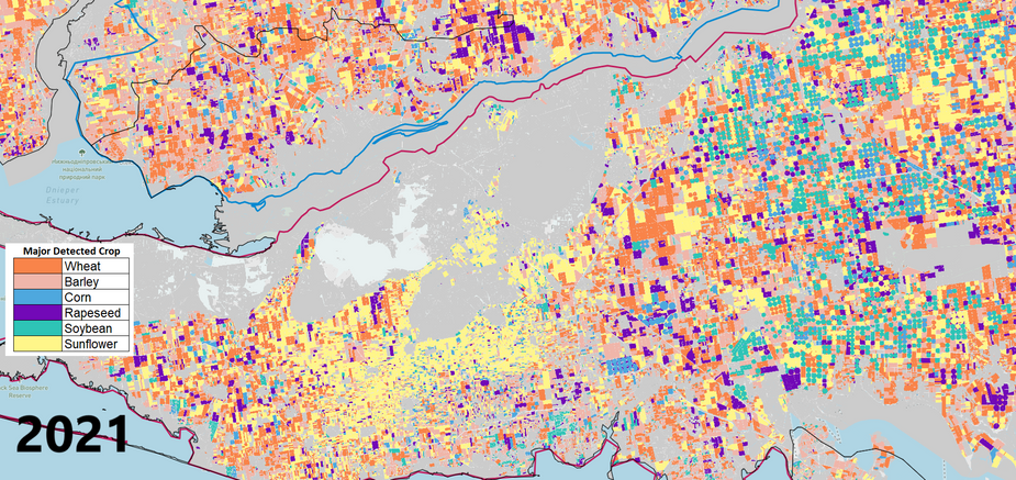
Below, we present satellite data comparing crop yields between 2021 and 2023, the first year in which the conflict impacted agricultural production. In 2023, significantly more sunflowers were sown than wheat. The number of uncultivated fields, especially along the front lines, also sharply increased. The disappearance of irrigated crops in the Kherson and Zaporizhzhia Regions is noticeable, as the areas in gray indicate abandoned, uncultivated, or non-arable land.
Impact of the Khakova Dam’s Irrigation Systems Destruction
Below, the direct impact of the Kakhovka Dam’s destruction of irrigation systems can be visualized. Soy and corn fields that were previously irrigated disappeared, and the sown areas of wheat and other crops also shrank.
Frontline Impact on Agricultural Production
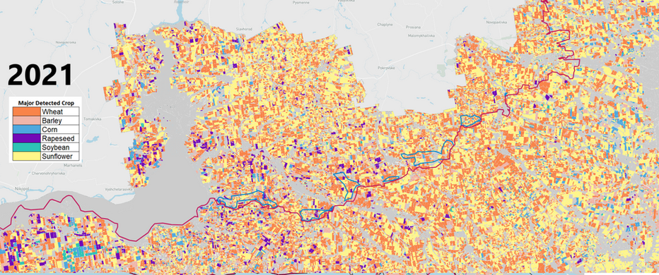
The images below present the impact of the front lines on the Zaporizhzhia Region's agricultural production: some fields have been abandoned, and sunflowers are now planted instead of wheat.
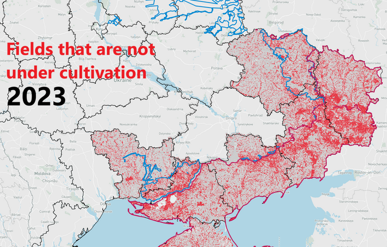
The volume of agricultural land that stopped being cultivated in both occupied and non-occupied territories in the six regions (those described above, excluding Kharkiv, which is no longer under Russian occupation) totaled approximately 3.5 million hectares. This uncultivated land could have produced more than 15 million tons of agricultural products each year, enough to feed approximately 70 million people for a year.
Below, you can see the impact of military actions on crop cultivation, or lack thereof. Near the front lines, many fields are abandoned due to constant danger. The presence of landmines explains the lack of cultivation in liberated regions. Russian forces heavily mined formerly arable lands, further impeding agricultural recovery.
Conclusion
Overall, these images and data demonstrate how Russia has deliberately impacted Ukraine’s agricultural production as a war objective. In general, arable and sown land dropped from 2021 to 2024. The Russians also changed the distribution of crops to one that favored them, for example, replacing wheat with sunflowers. Additionally, the Russians have rendered a significant proportion of Ukrainian land uncultivable as a consequence of their invasion. This is either a direct impact of hostilities, such as land near the front lines or areas hit by attacks, or the result of farmers avoiding cultivation due to the threat of new attacks or land being mined.
Sources
[1] For example, see “Agricultural War Damages Review Ukraine - Rapid Damage Assessment,” Center for Food and Land Use Research at Kyiv School of Economics, Jun. 8, 2022, https://kse.ua/wp-content/uploads/2022/06/Damages_report_issue1-1.pdf, last accessed Sep. 30, 2024; and confirmed by PEJ Witness Statements (P010 Jan. 25, 2023; P012 Sep. 30, 2022; P013 No date; P115 Jan. 16, 2024; P128 Jan. 19 2024; P129 Jan. 16, 2024; and P131 Mar. 3, 2024).
[2] Josep Borrell Fontelles (@JosepBorrellF), “Another Russian missile strike contributing to the global food crisis…,” Twitter, Jun.6, 2022, https://x.com/JosepBorrellF/status/1533870695586971648, last accessed Jan. 15, 2025; “РФ вперше застосувала проти України радянську ракету Х-59” [Russia has used the Soviet X-59 missile against Ukraine for the first time], Defense Express, Apr. 4, 2022, https://defence-ua.com/weapon_and_tech/rf_vpershe_zastosuvala_proti_ukrajini_radjansku_raketu_h_59_foto-6797.html, last accessed Jan. 15, 2025.
[3] Part of Kharkiv Oblast was temporarily occupied in February 2022, but almost all was liberated in November the same year.
[4] An oblast in Ukraine, sometimes translated as region or province, is the main type of first-level administrative division of the country.
[5] Focusing on Kherson, Zaporizhzhia, Luhansk, Mykolaiv, Kharkiv and on the Russian Grey grain fleet illegally exporting agricultural commodities from Crimea.
[6] Arable land is Ukraine agricultural land used to grow wheat, barley, corn, rapeseed, soybeans, sunflower, rye, millet, buckwheat, peas, and others.
[7] PEJ has issued two analytic reports on pillage patterns in the occupied southern Oblasts of Kherson and Zaporizhzhya where the Russians illegally seized the assets of at least 100 Ukrainian agricultural companies and gave them to Russian proxy companies since the beginning of the full-scale invasion in 2022.
[8] We will refer as “controlled land” to land under Ukrainian control and as “occupied land” to land under Russian occupation.
%20white.png)


